How does the Route Planner work?
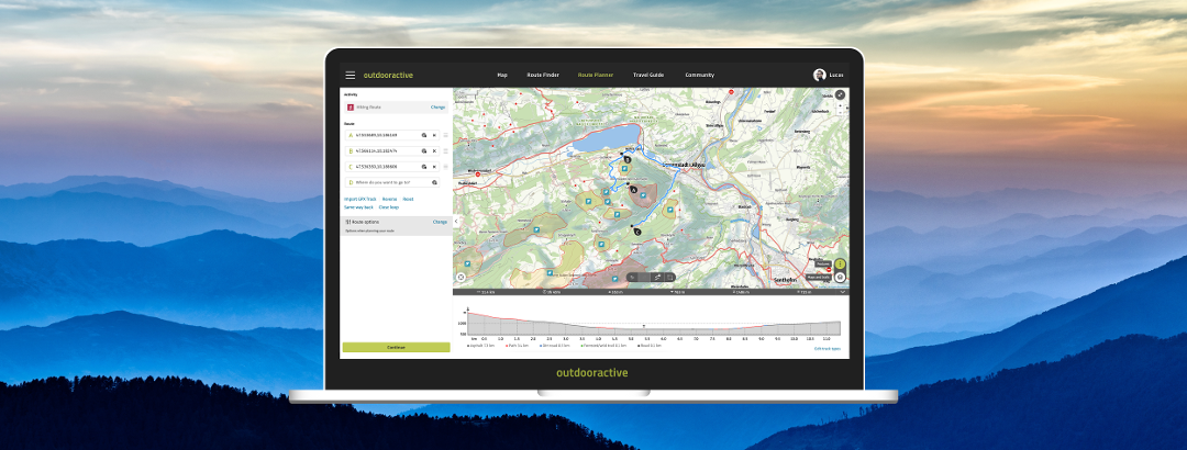
Plan your perfect route with just a few clicks. Choose your activity and set the individual waypoints directly on the map. Or simply enter the start and finish points and let our planner calculate the best route for you!
Creating a plan or route
You can find the route planner in the main menu under "route planner".
Before you start to planning, you should first decide on the activity you want to do. This is important because the automatic routing via the route network selects the routes according to your activity and also includes them in the calculation of the duration.
There are three possibilities when creating your plan or route:
- Enter the start and end points under "Route" on the left of the map. The route planner will now suggest the best route for your chosen activity. Of course you can not only enter the start and end point, but also other intermediate destinations. You can delete the individual points with the "X" or change the order by holding down the three bars on right.
- Mark the starting point and the course of your route by clicking on the map. Use the right mouse button to edit the route.
- Import a GPX file by using the button "Import GPX". The GPX route is now shown in the route planner and you have the possibility to edit it.
By clicking on "Reverse" you can change the direction of the route, by clicking on "Reset" you discard your planning.
How does the route planner in the app work?
The route planner has the same design on iOS and Android devices.
You can access the Route Planner via the main menu → "Plan".
To get into the route planner, first go to the map symbol in the main menu. Either you can start right away by pressing and holding the map or you tap the green route symbol in the upper right corner.
By pressing and holding the map you can set individual waypoints. Alternatively you can enter a location or an address in the list view for the waypoints. The list view can be found in the upper right corner of the map under the button "A,B,C". Set the corresponding activity for your route in the menu at the bottom left using the drop-down arrow. Use the two arrows in the middle of the menu to undo or redo the last editing step.
Altitude profile and trail types
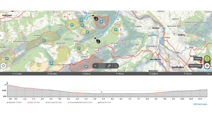
Below the map you will see the altitude profile and the trail types. You can show or hide this view by using the arrow on the far right in the grey bar. If the route types are not shown but are known, you can enter them manually by using the button "Edit route". First select the desired trail type and then select the section you want to change, either in the elevation profile or in the course of the route. Don't forget to save your changes!

Good to know
- Below the map, the grey bar shows you the length, duration, ascent and descent, as well as the highest and lowest point of the route.
- Use the full-screen symbol (two arrows) at the top right of the map to switch to the full-screen view of the route planner for even clearer planning
- Zoom in on the map by using the "+" and "-" icons in the upper right corner of the map. You can also use your mouse wheel or laptop's touchpad.
- Move the map by holding down the left mouse button.
- Free input lets you manually set your route using straight lines. you would use this if, for example, the routing engine does not automatically provide you with the geometry you want or you simply need to make adjustment. You can activate this function at the bottom center of the map using the button marked with the icon of an arrow on a line leading to a point.
- If you want to change the course of the route afterwards, you can insert an intermediate point on the route with a right-click and move it as you like. With right-click, you can also connect the points directly or connect freely routed sections on the route.
- Select your preferred map and style in the map list at the bottom right and choose to have route networks and additional layers displayed.
- With the two "forward" and "back" arrows you can undo or restore your last action.
- Use the green button with the three dots at the bottom right of the map to display various content and additional functions such as "My Map", "BuddyBeacon" or the "AudioGuide". This is also where you can import GPX files here.
- Use the "More" button at the bottom right of the map to view "My map" and various content, or import your GPX file.
- With the selection icon (at the bottom center of the map, the small square) you can select several points and then delete them or move the entire selection. Choose "New selection" to change your selection. You close the selection tool by using the "X" in the upper right corner or by clicking on the symbol again.
- The route planner works on the mobile website as well as in the app.
- Both in the app and on the web, you can easily plan a circular route. Set your waypoints that mark the first part of the loop. Click on the waypoint that represents the beginning of your loop. Select "Route to here" and the loop will be created automatically.
Save as a route or a plan?
After clicking on "Next" a 'plan' will first be created, which you can later edit and expand to create a full 'route'. You can name your plan, add a short description and confirm the activity. Save your edits by clicking on "Save plan".
If you want to create a route directly from a plan, click on "Plans" followed by the green button "Create route" in the upper right corner. When creating a route look to add wider information such as directions, details, and pictures. This makes it better for publishing and sharing with the Community.
Preparing a route
A route can be enriched with wider information and images:
- Under "Media" you can add photos and videos.
- Under "Description" enter a description, a route description, start and finish. In addition, you can add an author's tip, safety instructions, equipment and further information and links.
- Under "Details" you can enter an author's rating, rate the difficulty of the route according to physical condition and the SAC hiking scale, and indicate the best time of year for the route. If the calculated values for the duration and altitude difference of the route do not correspond to reality, you can also adjust or round off the values and assign the appropriate values. With the help of these properties, the routes can be filtered later in the route search.
- In the tab "Approach" you can specify if and how the route can be reached by public transport, the best way to get there and if parking is possible at the starting point of the route.
Can I plan routes in offline mode without an internet connection?
Routes and maps can be saved offline. However, it is not possible to plan routes on a map saved offline. In route planning, data is required for routing, which must be loaded via our system and therefore via an internet connection.
So, if you want to make changes to a route or plan one from scratch, you will need either a mobile data or WiFi connection.
What's new?
The tour planner has been given a modified design on the web. Certain features can now be found in the bar below the map. Also the option to import a GPX file.
There is also the option "Follow path" which replaces the airline option. If "Follow path" is activated, the planning is placed on the corresponding route network. If not, the points are connected as the crow flies and appear as a dashed line on the map.
An adjustment in the app will follow.
